![]()
Death Stranding Interactive Maps
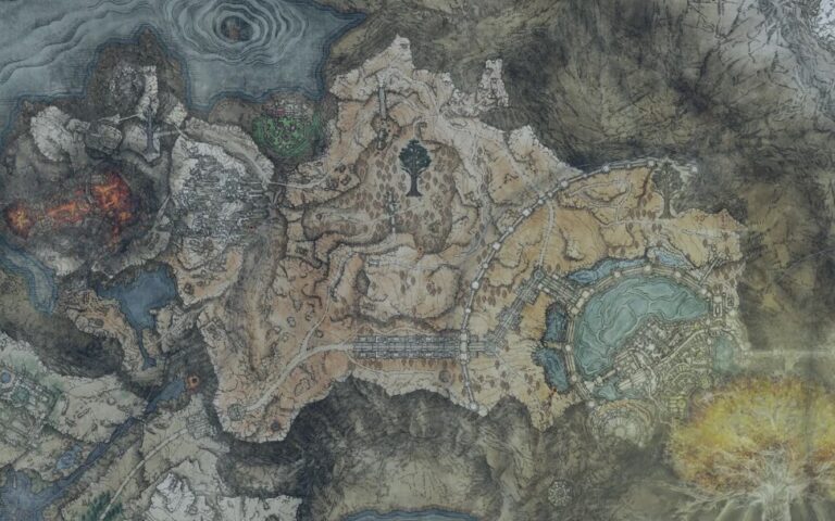
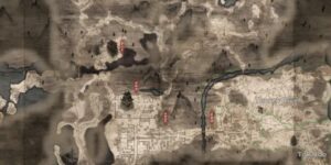
The Death Stranding Director’s Cut Map brings both the Eastern Region and Central Region together into one complete view of delivery routes, enemy zones, collectibles and facility locations. Since it also functions as a full Death Stranding Director’s Cut Interactive Map, it helps players understand how each region is structured and how key elements such as BT Territories, MULE Camps, Memory Chips and UCA Facilities spread across the world. These regions differ in scale, terrain and activity density, but the unified map makes it easier to plan routes, manage cargo demands and locate essential resources. Because traversal is central to the game, seeing all regions together provides a strong foundation for efficient deliveries, safe travel planning and exploration of hidden or optional content. Whether you are hunting Memory Chips, linking Prepper Shelters or navigating hostile territory, the combined map shows everything in one clear layout.
How to Use the Death Stranding Director’s Cut Maps
- Collectible categories include Memory Chips in both regions.
- Enemy categories include BT Territories, MULE Camps and Jellyfish Swarms depending on region.
- Facility categories include Prepper Shelters, UCA Facilities and Points of Interest.
- Location categories include Auto-Pavers and Hot Springs in the Central Region.
- Material categories include Chiral Crystal and Cryptobiote nodes.
- Misc categories include Easter Eggs in the Central Region.
- These categories support traversal, upgrades, scanning, delivery planning and exploration.
What the Map Can Do
Regional Coverage Overview
The Death Stranding Director’s Cut Maps show how the Eastern Region and Central Region offer different experiences for couriers. The Eastern Region is smaller and focuses on early-game learning, with Memory Chips placed in accessible yet subtle locations. BT Territories appear in specific zones and introduce players to the core threat that defines traversal. MULE Camps in the Eastern Region are relatively limited, making this area more forgiving for new players. Prepper Shelters in the East show early character interactions, while UCA Facilities help shape the first major delivery network. Chiral Crystal nodes appear in several places and support equipment fabrication and upgrades.
The Central Region offers a much larger landscape with a higher density of activity. Memory Chips become more numerous and appear in harder-to-reach areas. BT Territories expand significantly and cover more varied terrain, from mountainsides to plains. Jellyfish Swarms introduce additional airborne threats that require caution. MULE and Terrorist Camps appear more widely in this region and influence cargo-safe travel zones. Auto-Pavers become essential as players rebuild roads across the region. Hot Springs appear across the landscape and provide rest stops. Prepper Shelters and UCA Facilities form a dense network that drives the main progression.
Together, these two regions create a world that evolves from introductory routes to large-scale delivery planning, with hazards and opportunities expanding as players move west.
Enemy, Resource and Facility Distribution
Enemy distribution plays a major role in route planning. BT Territories in the Eastern Region appear as early tests, while Central Region BT zones span larger areas and often cover routes with uneven terrain or limited visibility. Jellyfish Swarms add airborne threats not found in the Eastern Region and require more mindful scanning. MULE and Terrorist Camps become more common in the Central Region and force players to choose between stealthy paths, avoidance or direct disruption. Because enemy types differ between regions, the unified map helps players decide when to approach high-risk zones or avoid them entirely.
Resources also influence progression. Chiral Crystals appear in both regions and support fabrication, upgrades and PCC usage. Larger concentrations in the Central Region encourage more frequent harvesting. Cryptobiote nodes appear as small clusters and help with survival, especially when BT encounters become more intense. Memory Chips serve as hidden collectibles, revealing story details or unlocking cosmetic items. The Eastern Region contains fewer chips, while the Central Region introduces larger hunts that reward exploration.
Facility distribution shapes how players link the world into the UCA network. Prepper Shelters provide character quests, upgrades and unique equipment. UCA Facilities serve as major connection points and provide essential terminal functions. Points of Interest across both regions highlight unique environmental or narrative elements that complement exploration. Auto-Pavers in the Central Region represent key infrastructure, allowing players to create stable road networks. Hot Springs act as natural resting points and provide small stat benefits or stress relief.
Exploration Flow, Delivery Planning and Late Game Value
The Death Stranding Director’s Cut Interactive Map helps players plan efficient routes across the two regions. Early game players can use the Eastern Region as a structured training ground for learning route planning, cargo balance, safe scanning and terrain navigation. Since threats are fewer, players can practice movement systems and experiment with tools before entering more complex zones.
The Central Region expands every system dramatically. Longer slopes, harsher terrain and deeper river beds challenge players to plan safer paths. Bridges, ziplines, roads and ladders become critical tools, and facility distribution helps shape navigation choices. Knowing where MULE Camps sit helps players avoid cargo-hungry enemies, while BT Territories influence when to move, how much cargo to carry and what tools to bring. Auto-Pavers help build long-term infrastructure, and the map’s clear layout helps players decide which stretches of road to repair first.
Memory Chip hunting becomes a more deliberate activity once players gain better gear. Prepper Shelters provide upgrades such as boots, exoskeletons or backpack features that influence efficiency. Hot Springs offer rest and recovery during long journeys, while Chiral Crystal clusters help maintain structure building momentum.
Together, these categories reveal how delivery planning, resource gathering and world linking work across both regions. The combined map helps players decide when to travel light, when to take on heavy deliveries and how to explore safely without unnecessary risk.
Map Table
Here is a quick overview of several important categories in Death Stranding Director’s Cut.
| Category | Example Item | Type |
|---|---|---|
| Memory Chip | Collectible Chip | Collectible |
| BT Territory | Hostile Zone | Enemy |
| UCA Facility | Distribution Center | Facility |
| Auto-Paver | Road Module | Location |
| Chiral Crystal | Chiral Deposit | Material |
FAQs
Does this map include both regions
Yes. The Eastern Region and Central Region are combined into one full Death Stranding Director’s Cut Map.
Where can I find Memory Chips
Both regions contain Memory Chips, with the Central Region holding a larger number.
Are BT Territories included
Yes. All BT zones appear across both regions, showing where stealth travel is required.
Do all major facilities appear on the map
Yes. Prepper Shelters, UCA Facilities and all Points of Interest are included.
Is this the complete Death Stranding Director’s Cut Interactive Map
Yes. Every category across both regions appears in this full map overview.
Credit: Death Stranding Map by Wand